Senin, 07 Agustus 2017

Precisely the road to the village Tongging Lake Toba with beautiful panorama and interesting, you can bring the family to camp on this hill.
Camp Grounds at Bobok Gajah Hill
To reach the area of elephant tourist attraction lakes of Toba lake, it only takes approximately 4 hours from the city of Medan,
To get here many roads that must be taken with caution, because the road is still not good to pass.
You can go to tourist area of elephant hill bobok by using wheel 2 and wheel 4.
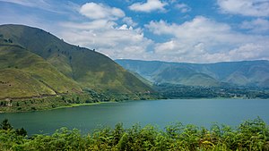
From this beautiful hill, you can enjoy the beauty of one of the largest lake in the world,
Namely toba lake, and can see clearly, simalem park resort from the top of the hill.
Beautiful Lake Toba From Bukit GajahBobok
Enjoying the beauty of nature is very useful to do brain refreshment,
Both from exhausting daily activities, from this hill,
We can see how beautiful lake Toba with water that reflects light in the morning,
Can make us reflective of the beauty of God Almighty with a beautiful view of sunrise in this place.
From this peak, you can enjoy the scenic hills and mountains that surround the lake Toba clearly,
One of the best is mountain sinabung, sibayak mountain scenery, buhit pusuh mountain,
And also the most famous is samosir island,
Waiting for Sunrise at Bukit Gajah Bobok Danau Toba Brand
I suggest if you want to camp or camp in this hill area,
Please provide supplies of food and beverages due,
In this hilltop elephant area there is nothing to sell food and drink.
Bukit Gajah Bobok

From a distance Sigura Gura waterfall looks so amazing, even the sound of water boom falling down was heard from the kajauhan because of its heights. Sigura Gura Waterfall comes from the water of the Asahan River whose water source comes from Lake Toba. The name of water tejun Sigura Gura is very popular among the tourists, in addition to the existence of an artificial dam that is right in front of it as a tourist attraction, the river in aliri water TerjunSigur gura is also often a place of exploitation as the arena of National and International Rafting competitions.
Sigura Gura Waterfall

Pulau Pasumpahan is an island located in the waters of Bungus Kecamatan Teluk Kabung, Kota Padang, West Sumatera. Therefore the island is close if we use the speed boat from Bungus Bay which is located near the city of Padang. Claims for the beauty of the sea makes this island began to be known by local and foreign tourists.
Pulau Pasumpahan area of about 5 hectares and has a stretch of white sand with clear water. Interestingly that the sea level of this island as divided into three. Clear color on the edge, green in front of it, and blue on the more to the middle. The depth of marine waters around the island is the cause of the color difference.
Potential underwater tourism in the marine tourism area of the west coast of Padang is a coral reef ecosystem area that is found in almost every island, including in Pulau Gosong. Apart from coral reef various types of reef fish or ornamental fish is also very interesting for tourists to enjoy. It is said that the story of this island is believed to be a resident around Malin Kundang incarnate who was sworn (cursed) his mother to stone. The inhabitants believe that Malin Kundang is condemned to stone on this island because of the associated 'spill'.
Pasumpahan Island is located on the west coast of Padang City. Its location is to the west of Little Devils Island or 200 meters from Sikuai Island. Exactly in the waters of Bungus District Teluk Kabung, Padang City. To reach the Pasupahan from the Banana River is by boat wooden or speedboat approximately 35 minutes with the cost of 40 thousand rupiah per person round trip with 45 PK engine. However, the searchers can negotiate rent a boat with a rental price of Rp 80 thousand with a capacity of 10 people. But if the searchers want to go straight to Pasumpahan Island Padang city then it can also rent a fishing boat from Bayur Bay Harbor.
Pasumpahan Island has a very beautiful scenery so it is not surprising if the local and foreign investors are scrambling to develop this island as a leading tourist attraction in West Sumatra. The sand along the Pasumpahan beach, accompanied by waves crashing into the main attraction of this beach. A small island floating off the coast, a bonus worth a sight. The sprawling beach stretch of billions of white sand grains, the quiet atmosphere is the main attraction of this island.
Thus, searchers will feel isolated away from the hubbub of the city even though it is only a step from the city crowd. In Pasumpahan Island, the searchers can perform activities such as snorkeling, swimming, diving, and also traveling around the island of spill. By walking then the searchers can see the natural scenery around the island so pamper the eyes.
Because Pulau Pasumpahan is a remote place then when traveling here the searchers do not forget to bring personal medicines, anti-mosquito lotion, sun block, food and drink enough and also tents to stay. The searchers will never regret a trip to Pulau Pasumpahan because this island is the most beautiful island in West Sumatra.
Hotell... Click Aja Disini!!!
Kasumpahan
Mount Kerinci (also spelled Kerintji, among several other ways, and referred to as Gunung Kerinci, Gadang, Berapi Kurinci, Kerinchi, Korinci/Korintji, or Peak of Indrapura/Indrapoera) is the highest volcani in Indonesia, and the highest peak on the island of Sumatra. It is surrounded by the lush forest of Kerici Seblat National Park, home to the endangered species of Sumatran Tiger and Sumatran rhinoceros.

Rekomendasi Hotel Clik Disini Aja!!!!
Mount Kerinci
Senin, 31 Juli 2017
Jam Gadang is located in central Bukittinggi, a city in the Minangkabau Highlands of West Sumatra. It sits in the middle of the Sabai Nan Aluih Park, near the Ateh Market and palace of Mohammad Hatta. The structure was built in 1926, during the Dutch colonial era, as a gift from Queen Wilhelmina to the city's controleur. It was designed by architects Yazin and Sutan Gigi Ameh, reportedly at a cost of 3,000 guilder.
Originally a rooster figure was placed on the apex, but it was changed into a Jinja-like ornament during the Japanese occupation (1942–1945). Following Indonesian independence, the tower's top was reshaped to its present form, which resembles traditional Minang roofs (see Rumah gadang). Local oral tradition holds that the internal mechanisms of the clock are twin to those of Elizabeth Tower (Big Ben) in London.
On March 6, 2007, the Jam Gadang tower was damaged by two earthquakes that struck western Sumatra. Over the following years it was refurbished by the Indonesia Heritage Trust (Badan Pelestarian Pusaka Indonesia). Funding for the 600 million rupiah(approximately 55 thousand Euros) restoration came from the Netherlands. The refurbished tower was inaugurated on December 22, 2010, as part of Bukittinggi's 262nd anniversary celebrations.
The Jam Gadang tower has been as an observation posts during fires, such as one that affected the Ateh Market. During Ramadhan, the call to prayer that marks the breaking of the fast is sounded from the tower.

Jam Gadang
 The Japanese bunker in the town of Bukittinggi was built by Indonesians under forced labor for the Japanese soldiers who occupied Indonesia from 1942 to 1945. This 1,470 meter long underground bunker is 40 meters below Ngarai Sianok (Sianok canyon). There are 21 tunnels in the bunker which were used to store ammunition, as residences, meeting rooms, the Romusha (forced laborer) dining room, kitchen, prison, hearing room, torture room, espionage room, ambush room, and the escape gate. Exploring this complex burrow of tunnels and caves is a real adventure.
 You can see how these this place made an effective fortress. The tunnels are three meters in diameter and have walls so thick that sounds cannot be heard from the outside. The tunnels cover a vast area, nearly two hectares, and have six doors. One door is located in Panorama Park while others access Sianok village in the Ngarai Sianok ravine.
Japanese Tunnel Bukittinggi

Take a trip into the wild with an adventure to the Mentawai islands. Be surrounded by tropical rainforests and immerse yourself in the traditions of the local people. While the physical distance between the mainland and Mentawai is not great, this remains one of the most isolated places in Indonesia, and was only subject to outside influences at the start of the 20th century. A long way from the world of shopping malls and theme parks, this is where travellers come to get a truly off the beaten track adventure.
The remote location of this island means that the Mentawai people have had very little contact with the outside world. The archipelago is tought to have broken off from the rest of Sumatra about 500,000 years ago and it is only since the 20th century that outside influences began to have an impact on the local people. Today, the Mentawai still abide by tradisional practices and live largely off the land. local peoplw have a strong spiritual relationship with the forest with a belief system that emphasizes harmony with creation. the other big attraction for visitors to these island is the world class surfing. with osme of the best surfing condition in the world, monster waves and swells that remain all year round, this is ranked by serious surfers as a must visit destination.
Recomended Hotelss!!!!!
Mentawai Island
Senin, 24 Juli 2017
Lake Toba is a large natural lake occupying the caldera of a super volcano. The lake is about 100 kilometers long, 30 kilometers wide, and up to 505 meters (1,666 ft) deep. Located in the middle of the northern part of the Indonesian island of Sumatra, with a surface elevation of about 900 meters. It is the largest lake in Indonesia and also the largest volcanic lake in the world.
Lake Toba is the site of a massive super volcanic eruption estimated at VEI 8 that occurred 69,000 to 77,000 years ago, representing a climate-changing event. It is the largest known explosive eruption on Earth in the last 25 million years. According to the Toba Catastrophe theory, it had global consequences for human populations; it killed most humans living at that time and is believed to have created a population bottleneck in central east Africa and India, which affects the genetic make up of the human worldwide population to the present.

Samosir, or Samosir Island, is a large volcanic island in Lake Toba, located in the north of the island of Sumatra in Indonesia. Administratively, Samosir Island is governed as six of the nine districts within Samosir Regency. The lake and island were formed after the eruption of a supervolcano some 75,000 years ago. The island was originally connected to the surrounding caldera wall by a small isthmus, which was cut through to aid navigation.
At 640 square kilometres (247 sq mi), Samosir is the largest island within an island, and the fifth largest lake island in the world.It also contains two smaller lakes, Lake Sidihoni and Lake Aek Natonang. Across the lake on the east from the island lies Uluan Peninsula. The island is linked to the mainland of Sumatra on its western part by a narrow isthmus connecting the town of Pangururan on Samosir and Tele on mainland Sumatra. Tele consequently offers one of the best views of Lake Toba and Samosir Island.
Here is some place you can visit in Samosir Island.
1. Pasir Putih Parbaba


Samosir Island
Langganan:
Komentar
(
Atom
)


